


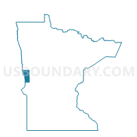
Wolverton Voting District, Wilkin County, Minnesota
About
Outline

Summary
| Unique Area Identifier | 604897 |
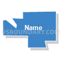
| Name | Wolverton Voting District |
| County | Wilkin County |
| State | Minnesota |
| Area (square miles) | 0.29 |
| Land Area (square miles) | 0.29 |
| Water Area (square miles) | 0.00 |
| % of Land Area | 100.00 |
| % of Water Area | 0.00 |
| Latitude of the Internal Point | 46.56349770 |
| Longtitude of the Internal Point | -96.73650120 |
Maps


Graphs
Select a template below for downloading or customizing gragh for Wolverton Voting District, Wilkin County, Minnesota


Neighbors
Neighoring Voting District (by Name) Neighboring Voting District on the Map
- Richland 25-11 Voting District, Richland County, ND
- Wolverton Twp. Voting District, Wilkin County, MN
Top 10 Neighboring County Subdivision (by Population) Neighboring County Subdivision on the Map
- Eagle township, Richland County, ND (252)
- Wolverton city, Wilkin County, MN (142)
- Wolverton township, Wilkin County, MN (128)